
New UN map charts reality of West Bank
By Sharmila Devi and Harvey Morris in Jerusalem
June 4 2007
A new map of the West Bank (see below), 40 years after its conquest by Israel in the Six Day War, gives the most definitive picture so far of a territory in which 2.5m Palestinians are confined to dozens of enclaves separated by Israeli roads, settlements, fences and military zones.
A new map of the West Bank (see below), 40 years after its conquest by Israel in the Six Day War, gives the most definitive picture so far of a territory in which 2.5m Palestinians are confined to dozens of enclaves separated by Israeli roads, settlements, fences and military zones.
Produced by the United Nations's Office for the Co-ordination of Humanitarian Affairs, it is based on extensive monitoring in the field combined with analysis of satellite imagery. It provides an overall picture
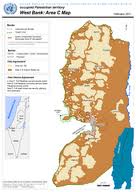
officials say is even more comprehensive than charts drawn up by the Israeli military.
The impact of Israeli civilian and military infrastructure is to render 40 per cent of the territory, which is roughly the size of the US state of Delaware or the English county of Norfolk, off-limits to Palestinians.
The rest of the territory, including main centres such as Nablus and Jericho, is split into isolated spots. Movement between them is restricted by 450 roadblocks and 70 manned checkpoints.
The UN mapmakers focused on land set aside for Jewish settlements, roads reserved for settler access, the West Bank separation barrier, closed military areas and nature reserves.
What remains is an area of habitation remarkably close to territory set aside for the Palestinian population in Israeli security proposals dating back to postwar 1967.
The process of enclosing the civilian enclaves has accelerated in the years since the outbreak of the Palestinian uprising in 2000, and the reintroduction by Israel of its military rule even in areas previously under Palestinian Authority security control.
A network of roads designed to ease the movement of Jewish settlers limits access between Palestinian enclaves. A secondary network being built would allow Palestinian limited movement via tunnels, bridges and trenches.
Diplomats say the effect of the infrastructure changes would be to formalise the de facto cantonisation of the West Bank. Some 450,000 Israelis live in the West Bank and occupied east Jerusalem and settlements have grown by at least 5.5 per cent a year compared with less than 3 per cent among Palestinians.
The map is one of a number of documents whose publication has coincided with Monday's anniversary of the 1967 war. Amnesty, the rights group, issued a report that accused Israel of a land grab in the West Bank and called for urgent action to address "widespread human rights abuses committed under the occupation".
The Israeli justice ministry branded the report as "one-sided, immoral and riddled with mistakes".
The 52-pg Amnesty International Report, Enduring Occupation, which is mentioned toward the end of the article below may be found and downloaded here